 はじめに
はじめに お問い合わせ
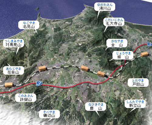
その山地や丘陵は、北部に城山から孔大寺山に連なる急峻な孔大寺山地(四塚山地・四塚連山とも呼ぶ)が見られ、南部には磯辺山や許斐山などの低い山々の連なる宗像・鞍手低山地がある他は、宗像丘陵と総称される丘陵群から構成されています。
市内からは、むしろ福智山塊や三郡山地などの市域外の山並みがよく遠望できます。
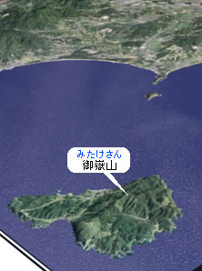
(左は大島にある御嶽山)
宗像市は、釣川下流部を除くと、全体として周りを海抜200~400m前後の低い山地や丘陵に囲まれた盆地状の地形をしています。
|
名前(よみ)
|
標高
|
|---|---|
| 湯川山 (ゆがわさん) | 471m |
| 孔大寺山 (こだいじさん) | 499m |
| 金山 (かなやま) | 317m |
| 城山 (じょうやま) | 369m |
| 戸田山 (とだやま) | 267m |
| 新立山 (しんたてやま) (別名:権現山(ごんげんやま)) |
325m |
■四塚連山(よつづかれんさん)
|
名前(よみ)
|
標高
|
|---|---|
| 磯辺山 (そべやま) | 232m |
| 許斐山 (このみさん) | 271m |
| 名児山 (なごやま) | 165m |
| 対馬見山 (つしまみやま) | 238m |
| 在自山 (あらじやま) | 249m |
| 御嶽山 (みたけさん) | 224m |
その山地や丘陵は、北部に城山から孔大寺山に連なる急峻な孔大寺山地(四塚山地・四塚連山とも呼ぶ)が見られ、南部には磯辺山や許斐山などの低い山々の連なる宗像・鞍手低山地がある他は、宗像丘陵と総称される丘陵群から構成されています。
市内からは、むしろ福智山塊や三郡山地などの市域外の山並みがよく遠望できます。
(左は大島にある御嶽山)
宗像市を囲む山々の中でも、北部に連ねる湯川山(ゆがわさん)、孔大寺山(こだいじさん)、金山(かなやま)、城山(じょうやま)の四つを総称して四塚連山と呼ばれています。
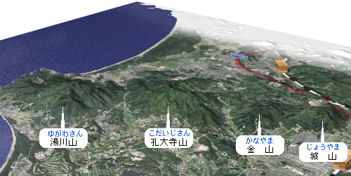
市を見守るように並ぶこの四塚連山は、新しい宗像市のフレームの一つ<自然環境保全ゾーン>の中にあり、自然豊かな宗像市のシンボルにもなっています。
一番高い孔大寺山が約500mと標高はそれほどありませんが、それぞれの山をめぐる登山道が整備されていて所々に休憩するところもありますので、年中通してこの"縦走"を楽しむ登山客が訪れています。
これらの山地や丘陵は、昭和20年代までは里山として利用され、宗像の緑に囲まれた森林景観を作っていましたが、近年では丘陵地の一部や低い山の一部を人工的に作り変えて、本来の姿から変わってしまった地形も少なくありません。
それらの一部は、用山地区のように山の斜面をブルドーザーで削って樹園地を造成したものや、朝町川上流部のように低い山の起伏の一部は残るものの本来の大部分を作り変えて、ゴルフ場を造成したり、さらには日の里地区のように全面的に丘陵を平坦化して、住宅地を造成した地域もあります。